Tehri Garhwal

 Lying on the southern slopes of outer Himalayas, Tehri Garhwal is on of the sacred hilly districts of Uttarakhand State. Before the creation of universe, Lord Brahma is said to have meditated on this sacred land. Muni-ki-Reti and Tapovan of the district are the places of penance for the ancient Rishis. Its hilly terrain and lack of easy communications have helped it to preserve its culture almost intact. Tehri and Garhwal are the two words combined for naming the district as Tehri Garhwal. While the prefix Tehri is the corrupted form of the word `Trihari` which signifies a place that washes away all the three types of sins, namely sins born out of thought (Mansa), word (Vacha) and deed (Karmana), the other part `Garh` means country fort. In fact during olden days possession of number of forts was considered as a significant measuring rod of the prosperity and power of their rulers. Prior to 888, the whole of the Garhwal region was divided into small `garhs` ruled by separate independent kings known as Rana, Rai or Thakur. It is said that the prince Kanakpal who hailed from Malwa visited Badrinath ji (presently in Chamoli district) where he met the then mightiest king Bhanu Pratap. King Bhanu Pratap was impressed with the prince and got his only daughter married to him and also handed over his kingdom. Gradually Kanakpal and his descendents extended their empire by conquering all the garhs. Thus up to 1803 i.e. for 915 years the whole of the Garhwal region remained under their control.
During 1794-95 Garhwal was under the grip of severe famine and again in 1883, the country was terribly shaken by an earthquake. Gorkhas had by then started invading this territory and heralded their influence over the region. The people of the region being already affected by natural calamities were in the deplorable condition and therefore could not resist Gorkhas invasion. On the other hand, Gorkhas whose several attempts for capturing the fort Langoor Garhi had earlier failed, were now in powerful position. In 1803, therefore, they again invaded Garhwal region when King Pradumn Shah was the ruler. King Pradumn Shah was killed in the battle in Dehra Dun but his only son (Sudarshan Shah was minor at that time) was cleverly saved by the trusted courtiers. With the victory of Gorkhas in this battle their dominion was established in Garhwal region. Later on their kingdom extended up to Kangara and they ruled over this region continuously for 12 years before they were thrown away from Kangara by Maharaja Ranjit Singh. On the other hand Sudarshan Shah could manage help from East India Company and got his kingdom freed from Gorkha rulers. The East India Company merged Kumaon, Dehra Dun and east Garhwal in the British Empire and the west Garhwal was given to Sudarshan Shah which was then known as Tehri Riyasat.
King Sudarshan Shah established his capital at Tehri town and afterwards his successors Pratap Shah, Kirti Shah and Narendra Shah established their capital at Pratap Nagar, Kirti Nagar and Narendra Nagar respectively. Their dynasty ruled over this region from 1815 to 1949. During the Quit India Movement people of this region actively participated for the independence of the country. Ultimately when the country was declared independent in 1947, the inhabitants of Tehri Riyasat started their movement for getting themselves freed from the clutches of Maharaja. Due to the movement the situation became out of his control and was difficult for him to rule over the region. Consequently the 60th king of Pawar Vansh Manvendra Shah accepted the sovereignty of Indian Government. Thus in 1949 Tehri Riyasat was merged in Uttar Pradesh and was given the status of a new district. Being a scattered region it posed numerous problems for expediting development. Resultantly on 24th February 1960 the U.P. Government separated its’ one tehsil which was given status of a separate district named as Uttarkashi.
Initially the Tehri Garhwal was an independent state ruled by Parmar rulers. Later on, when British occupation of Garhwal started (1815 onwards) the Tehri Garhwal state was administered for more than 13 decades (about 133 years) in a “Native style” i.e. it remained under a distinctly separate administrative system, which was modeled, more or less, on the pattern of British India. After India achieved its independence from the British in August 1947, Tehri for the next two years continued as a Native state, till by a Govt. of India proclamation of 1st August 1949, it too was integrated and became the part of the then Uttar Pradesh. This erstwhile Native state was later divided into Uttarkashi and Tehri Garhwal district of Garhwal Division. After the bifurcation of Uttar Pradesh, this district is now in the state of Uttaranchal, spread over 3796 Sq. Km.
Geography
Geographically, the Tehri Garhwal district can be divided into two main parts- (i) Valley and (ii) Hill Areas. Basically it is a hilly district as most of its area is mountainous. Soils of vallies are of Dumont and Red types while Red Dhumat is found in the hilly region.
As far as climate is concerned, hot climate is the characteristic of valise in summer and extreme colds in the winter. Higher peaks are snow clad throughout the year. The minimum and maximum (mean) temperatures vary between 0.20 C to 32 C respectively. Average rainfall in the district is 1706.8 mm.
Many rivers originate/ flow through this district; a few important of them are-Alaknanda, Bhagirathi, Bhilangana and many of these rivers are having religious importance for Hindus. The district has many important mountains/ glaciers-Khatling glaciers, Pidi Mountain, Nagtiba, Pawali-Kantha etc.
The forest area of the district is 67%. This forest cover of the district comprises of Deodar, Pine, Ralkher, Kharas, Moru, Mukkut etc. These provide valuable timber and non-timber forest products.
Lime, dolomite, Zinc, Phosphate etc. is also found in the district, which is under utilized mostly due to lack of good infrastructure.
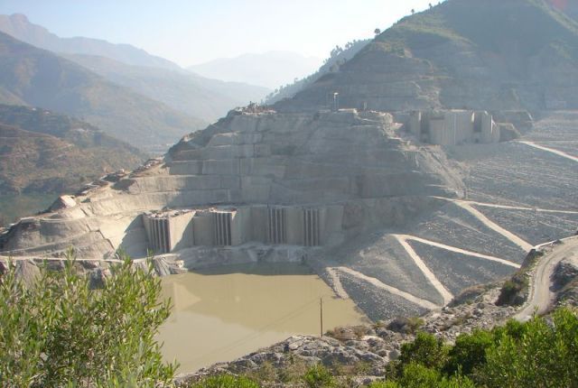
The much awaited Tehri Dam is on the verge of completion and is a major hope for the people of state in general and people of Tehri Garhwal district in particular. The dam has the height of 260.5 m. and is expected to generate 2400 MW. of electricity. Apart from power generation, irrigation, navigation, flood control, it will definitely enhance the employment opportunities in the sectors like tourism, fishing etc.
The physiographic and socio-economic conditions of this district are characterized by their diversity and complexity. The population of the region has increased rapidly with the consequence of mounting pressure on limited forest cover. This has led to increased use of marginal, easily eroded lands and overgrazing of fragile upland pasture areas. Further due to small land holdings, limited irrigation facilities and extreme (adverse) climatic conditions, the peasants of the region do not get desired income giving rise to a kind of “subsistence economy”.
In addition, the traditional sheep and goat rearing and wool-based activities have been diminished due to increasing literacy and ban posed through Govt. policies an grazing on the other. Consequently the traditional looms and weavers have become idle. Besides it there are no developed village and cottage industries.
Due to all these reasons the educated and uneducated unemployed youths are forced to migrate to the plains in search of job leaving behind their women folks in the villages to struggle for their life. Consequently, these circumstances have diverted the once “self reliant economy” to the “money order economy”.
Place of interest in Tehri
Tehri Dam
Tehri Dam is the tallest dam in Asia and the fourth tallest rockfill dam in the world sprawling over an area of 45 sq. kms in the Bhagirathi and Bhilangana valleys near Tehri town. It is expected to produce 2400 MW of electricity, provide irrigation and drinking water. But, the dam is being opposed by scientists and environmentalists, as it is considered to be an environmental catastrophe. Opponents of the project argue that this mamooth project is destined to be a failure.
Chamba
Chamba is perched at an altitude of 1,676mts above sea level in Tehri district of Uttarakhand state. Chamba is situated at one end of the Mussoorie - Chamba Road. Chamba is popular because of its unpolluted beauty and panoramic excursions. Chamba is frequently visited by tourists as Chamba offers tranquility and exquisiteness. Chamba is a picturesque hamlet situated in the laps of Himalayas. Chamba is successfully tempting tourists from a long time with its celestial and unrivaled beauteousness. Located amidst dense pine trees and deodar forests, Chamba offers invigorating views of the Himalayas.
Previously Chamba was a part of the Gorkha Kingdom but the Kings of Garhwal later ruled this place. Chamba is a scenic spot with natural splendors which lures the nature lovers throughout the year. Explore the pastoral life of the people living near villages in Chamba. Chamba is only two hours drive away from Rishikesh. The average literacy rate of Chamba is 76% which is higher than the national average literacy rate.
Charming Chamba, the idyllic resort is 48 kms from Narendra Nagar on the road to Gangotri. It affords spectacular views of the snow-capped Himalayas and the serene Bhagirathi valley. It has gained importance as routes for Mussoorie, Rishikesh, Tehri and New Tehri converge here. The Chamba-Mussoorie fruit belt is also famous for its delicious apples.
Shri Bageshwar Mahadev Mandir, the most popular temple of Chamba, Shri Bageshwar Mahadev is dedicated to Lord Shiva. The temple is at its glorious best on the day of Shivaratri.
Tourist Attraction
BUDA KEDAR TEMPLE
This temple is situated at the confluence of the Bal Ganga and Dharam Ganga rivers, at a motorable distance of 59 kms. from Tehri. It is believed that Duyodhan offered tarpana here.
According to legends, it is at this temple that the Pandavas encountered Rishi Balkhily at Bhrigu Parvat when they were on the lookout for Shiva after the Kurukshetra battle. The Rishi directed them to the site of the confluence to meet an old manmeditating there. But when the Pandava got there, the old man vanished and instead, a shivling appeared there. Rishi Balkhily instructed the Pandavas to embrace the Shivling in order to free themselves from their sins. Their impressions are stamped on this Shivling – the biggest Shivling in northen India.
Devprayag
The town is the seat of the pundits of Badrinath Dham. Some part of Devprayag comes under Pauri Garhwal district. Devprayag is the last prayag (confluence) of Alaknanda River and from this point the confluence of Alaknanda and Bhagirathi River is known as Ganga. The town lies on the Rishikesh-Badrinath highway, 71kms ahead of Rishikesh.
The town of Devprayag holds great religious importance amongst Hindus as the divine Ganga River takes its real form from here. The town is named after Dev Sharma who led his ascetic life here and it is also believed that he was blessed with a glimpse of god. The place showers the tourists with its serene and divine natural beauty and it is also believed than Lord Rama and King Dushratha did penance here. There is an ancient Raghunathji Temple built above the confluence with massive rocks and it is believed that the temple was built more than ten thousand years ago.
The structure of the town was devastated by an earthquake of 1803 but it was subsequently repaired. The confluence has Brahma Kund on Bhagirathi River and Vashisht Kund on Alaknanda River. There is a place called Baitalshila and it is claimed that a bath in it can cure leprosy. Devprayag can be visited anytime of the year but try to avoid the monsoons as the water is muddy and there are chances of roads getting blocked due to landslides.
The great temple of Raghunath Ji is claimed to have been erected some ten thousand years ago and is built of massive non cemented stones. It stands upon a terrace in the upper part of the town and consists of an irregular pyramid capped by a white cupola with a golden ball and spire. Religious ablutions take place at 2 basins excavated in the rock at the junction of the holy streams - on the Bhagirathi known as the Brahm Kund and the other on the Alaknanda called the Vasisht Kund. The temple, along with the other Buildings of the town, was shattered by an earthquake in 1803 but the damage was subsequently repaired through the munificence of Daulat Rao Sindhia. The temple is visited by a large number of pilgrims every year.
The town is the seat of the pandas of the Badrinath Dham and possesses a post and telegraph office, a public call office, a police out-post, a dak bungalow of the public works department and a hospital.
Besides the temple of Raghunathji, there are in the town Baital Kund,Brahm Kund,Surya Kund and Vasisht Kund; the Indradyumna Tirth,Pushyamal Tirth, Varah Tirth ; Pushpavatika ; Baitalshila and Varahishila ; the shrines of Bhairava, Bhushandi, Durga and Vishveshvara ; and a temple dedicated to Bharata. A bath at Baithalshila is claimed to cure leprosy.
Nearby is the Dasharathachal Peak, containing a rock, known as Dashrathshila, on which Raja Dasharath is said to have led a life of penance.A small stream, the shanta running down from the Dasharathachal, is named after Shanta, the daughter of Raja Dasharath and is considered to be sacred.
KHATLING GLACIER
The trek for Khatling glacier starts from Ghuttu, a place about 62 kms. from Tehri. There is a P.W.D. Inspection house and a Tourist Rest House at ghuttu. The other important places enroute are Reeh, Gangi, Kalyani & Bhomakgufa. At Reeh & Gangi Tourist Rest Houses are available. Gangi is the last village beyond which no facilities of any kind are available and one has to make its own arrangements. The singht of the khatling glacier is most spectacular and alluring. From here Masartal is 7 kms. The route further goes up to basukital and from there to Kedarnath.
NARENDRA NAGAR
14 kms. away from Muni-ki-Reti at an altitude of 1,129 mts. lies this capital of the former king of Garhwal.Until a few years ago it was the headquarter of the District Tehri Garhwal, but now the New Tehri Town is the headquarter. Here, the palace of the Tehri Raja, is situated amidst a forest.
Situated on the main Rishikesh-Gangotri-Yamunotri route, Narendra Nagar offers a fine view of the Ganga and the beautiful Doon Valley. The sun set view from here is particularly attractive. Hotels and the P.W.D. Inspection House offer accommodation.
Sem Mukhen
At a height of 2903 mts., situated in the interior of the district, the temple of Nag Raja at Sem Mukhem is held in high esteem by the people of the area. Transport facilities are available up to Khamba Khal, a distance of 64 kms. from Tehri. One has to walk for about 7 kms. from the Khamba Khal to reach Sem. The temple is situated at the top of a hill about 5 kms. from the village Mukhem which is 2 kms. from the motor head of Khamba Khal. Accommodation is provided by the ‘Pandas’ of the village Mukhem .
Chamba
60 kms. from Mussoorie and 48 kms. from Narendra Nagar on the road to Gangotri. Chamba is a township lying high at an altitude of 1676 mts., offering a splendid view of the snow-capped Himalayas and the serene Bhagirathi valley. Chamba happens to be a focal point, being located at the junction of roads leading from Mussoorie, Rishikesh, Tehri and New Tehri. The Chamba- Mussoorie fruit belt is also famous for its delicious apples.
Jal Nigam Rest House, Tourist Rest House, Hotel Akash Deep, Akash Lok, Neelkant, Social Palace & Hotel Classic Hill Top provide comfortable accommodation
Dhanaulti
Dhanaulti is perched at an astounding elevation of 2,286mts above sea level on Mussoorie - Chamba Road. Dhanaulti is located in the Tehri district of Uttarakhand state offering panoramic views. Dhanaulti is emerging as a popular weekend getaway from Delhi as it is easily accessible affording exquisiteness and tranquility. Dhanaulti showers tourists with natural beauteousness throughout the year; therefore it can be visited at any time of the year. During summers the place acts as a relief from the sultry conditions of the plains and during winters the place is covered with snow. Dhanaulti rests on the misty mountains amidst thick, virgin forests of Deodar, Rhododendron and Oak, has an atmosphere of perfect peace & tranquility. The long wooded slopes, relaxed outdoors, cool crossing breeze, warm and hospitable inhabitants, lovely weather and fabulous view of snow covered mountain makes it an ideal retreat for a relaxed holiday. Situated on the Mussoorie-Chamba route, Dhanaulti is 24 kms. From Mussoorie and 29 Kms. From Chamba.
Also written as Dhanolti, Dhanaulti is also popular because of its proximity with famous tourist spots like Mussoorie, Tehri and Chamba.
The pleasant weather, wooded slopes, invigorating vies of the snow capped peaks of the Himalayas adds peace and tranquility for the tourists visiting Dhanaulti. As Mussoorie has become crowded, many tourists love to retreat to Dhanaulti. Dhanaulti is unlike other hill stations as it is set in a quiet and quaint place away from the boisterous places. Dhanaulti offers luxury hotels and budget hotels as well.
Kunjapuri
Kunjapuri is the name given to a peak having an altitude of about 1,676 m. It lies in Lat. 30`11` N. and Long. 78`20` E., about 93 km. from Devaprayag and 7 km. from Narendra Nagar. It commands a beautiful view of the snow-ranges of the Himalayas and of the valley of the Bhagirathi. It contains an old temple dedicated to the goddess Kunjapuri Devi which is visited by a number of people every year. Nearby, in Agarakhal, there is a dak bungalow situated in picturesque surroundings and maitnained by the public works department. Kunjapuri is said to be one of the sidddhapeeths established in the region by Jagadguru Shankaracharya and legend has it that the upper-half of the body of Sati, wife of Siva, fell here when Siva was carrying it to Kailash after Sati had flung herself in the yajna fires when some derogatory remarks were made about her husband by her father Daksha
NEW TEHRI
The newly established township is the district headquater of Tehri Garhwal. It is situated at an elevation between 1550 to 1950 mts. Above sea level. A modern and well planned town, only 11 Kms. From Chamba & 24 Kms. From Old Tehri, it overlooks a massive artificial lake and a Dam. It will soon become an important centre of attraction on the completion of the dam.
How to Reach
By Air
Nearest is Jollygrant 93 kms
Rail
Rishikesh is the nearest railway station, 76 kms.
By Road
New Tehri is well connected by road to all important stations of Garhwal Division like Dehradun, Mussoorie, Haridwar, Pauri, Rishikesh, Uttarkashi etc. Private Taxies abd jeeps are available for trips to nearby towns of chamba & Tehri. Bus service connect to New Tehri to Tehri, Rishikesh, Haridwar, Dehradun, Mussoorie.
Surkanda Devi
The Surkanda peak lying at an altitude of 2,750 m. in the western part of tahsil Tehri, and is famous for the temple of Surkanda Devi. It is about 8 km. from Dhanolti on the motor road running from Mussoorie to Chamba and is connected with Narendra Nagar which is about 61 km. and with Tehri which is about 41 km. by motor roads. To reach the temple one has to leave the Mussoorie-Chamba road at Kadu Khal and climb a steep ascent of about 1.5 km. on foot. The legend is that Sati, the wife of Siva, gave up her life in the yajna started by her father. Siva passed through this place on his way back to Kailash with the dead body of Sati whose head fell at the spot where the temple of Surkhanda Devi stands. It commands a beautiful view of Dehra Dun, Rishikesh, Chandrabadni, Pratapnagar and Chakrata. Flowers of varied kinds and colours and indigenous herbs grown in abundance here and some of the beautiful birds of the western Himalayas are also found in the neighbourhood. A local fair is held on the occasion of Ganga Dasahra in Jyaistha when hundreds of devout pilgrims visit this place
CHANDRABADANI
The Chandrabadni a mountain (2,277 m. above sea-level) , lying in Lat. 30* 18’ N. and Long. 78* 37’ E.,on the border of tahsil Devaprayag and Pratapnagar is well known for the temple of Chandrabadni Devi which lies at the top of the mountain about 10 km. north of Kandi Khal ( a place on the Devaprayag-Kirti Nagar metalled road) , 22 km. from Devaprayag and 109 km. from Narendra Nagar. It is said that when sati, the wife of siva,gave up her life in the yajna started by her father and siva was carrying her body to Kailash, her torso fell here. There are some old statues and lots of iron trishuls (tridents) outside the temple. It comands a beautiful view of the Sirkanda, Kedarnath and Badrinath peaks. The temple here is very small and contains a Shri-yantra carved out on a flat stone instead of any idol. Traditionally, a cloth canopy is tied to the ceiling over this Shri-yantra once a year and the Brahmana priest doing it has to do it blind-folded.
15 Kms. from Mussoorie on the Yamunotri road having and altitude of 1215 mts. It has the distinction of being the biggest and prettiest water fall located in a beautiful valley and is surrounded by high mountains. A bath at the foot of the fall is refreshing and enjoyable for children and adults alike.
NAGTIBBA
For those who are instreted in trekking and adventure,Nagtibba offers them all the opportunities. The area is full of dense forests and natural beauty. One can have a panoramic view of the Himalayas. Thatyur is the base camp for visiting the place, it is away from Chamba-Mussoorie road for which roadbranches off from Suwakohli a place about 16 kms. From Dhanolti. From here Thatyur is 23 kms. Situated in the valley at the bank of river Algar. The trek starts from here, via Dewalsari, a place 7 kms. Whereone can stay in the forest rest house. From Dewalsari Nagtibba is 14 kms. Situated at an altitude of 3048 Meters and other glaciers is most spectacular and alluring. From here Masartal is 7 kms. The route further up goes to basukital and from there to Kedarnath.
| Tehri at a glance | |
| District Headquarters | New Tehri |
| Area | 4085 sq km |
| Population | 604,747 |
| Literacy | 67.04% |
| Altitude | 1550 mts. To 1950 mts. |
| Climate | Min. Temp. 40 C, Max. Temp. 300 C |
| Language | Garhwali, Hindi & English |
| Clothing | Summer – Cotton, Winter –Wollen |
 Lying on the southern slopes of outer Himalayas, Tehri Garhwal is on of the sacred hilly districts of Uttarakhand State. Before the creation of universe, Lord Brahma is said to have meditated on this sacred land. Muni-ki-Reti and Tapovan of the district are the places of penance for the ancient Rishis. Its hilly terrain and lack of easy communications have helped it to preserve its culture almost intact. Tehri and Garhwal are the two words combined for naming the district as Tehri Garhwal. While the prefix Tehri is the corrupted form of the word `Trihari` which signifies a place that washes away all the three types of sins, namely sins born out of thought (Mansa), word (Vacha) and deed (Karmana), the other part `Garh` means country fort. In fact during olden days possession of number of forts was considered as a significant measuring rod of the prosperity and power of their rulers. Prior to 888, the whole of the Garhwal region was divided into small `garhs` ruled by separate independent kings known as Rana, Rai or Thakur. It is said that the prince Kanakpal who hailed from Malwa visited Badrinath ji (presently in Chamoli district) where he met the then mightiest king Bhanu Pratap. King Bhanu Pratap was impressed with the prince and got his only daughter married to him and also handed over his kingdom. Gradually Kanakpal and his descendents extended their empire by conquering all the garhs. Thus up to 1803 i.e. for 915 years the whole of the Garhwal region remained under their control.
During 1794-95 Garhwal was under the grip of severe famine and again in 1883, the country was terribly shaken by an earthquake. Gorkhas had by then started invading this territory and heralded their influence over the region. The people of the region being already affected by natural calamities were in the deplorable condition and therefore could not resist Gorkhas invasion. On the other hand, Gorkhas whose several attempts for capturing the fort Langoor Garhi had earlier failed, were now in powerful position. In 1803, therefore, they again invaded Garhwal region when King Pradumn Shah was the ruler. King Pradumn Shah was killed in the battle in Dehra Dun but his only son (Sudarshan Shah was minor at that time) was cleverly saved by the trusted courtiers. With the victory of Gorkhas in this battle their dominion was established in Garhwal region. Later on their kingdom extended up to Kangara and they ruled over this region continuously for 12 years before they were thrown away from Kangara by Maharaja Ranjit Singh. On the other hand Sudarshan Shah could manage help from East India Company and got his kingdom freed from Gorkha rulers. The East India Company merged Kumaon, Dehra Dun and east Garhwal in the British Empire and the west Garhwal was given to Sudarshan Shah which was then known as Tehri Riyasat.
King Sudarshan Shah established his capital at Tehri town and afterwards his successors Pratap Shah, Kirti Shah and Narendra Shah established their capital at Pratap Nagar, Kirti Nagar and Narendra Nagar respectively. Their dynasty ruled over this region from 1815 to 1949. During the Quit India Movement people of this region actively participated for the independence of the country. Ultimately when the country was declared independent in 1947, the inhabitants of Tehri Riyasat started their movement for getting themselves freed from the clutches of Maharaja. Due to the movement the situation became out of his control and was difficult for him to rule over the region. Consequently the 60th king of Pawar Vansh Manvendra Shah accepted the sovereignty of Indian Government. Thus in 1949 Tehri Riyasat was merged in Uttar Pradesh and was given the status of a new district. Being a scattered region it posed numerous problems for expediting development. Resultantly on 24th February 1960 the U.P. Government separated its’ one tehsil which was given status of a separate district named as Uttarkashi.
Initially the Tehri Garhwal was an independent state ruled by Parmar rulers. Later on, when British occupation of Garhwal started (1815 onwards) the Tehri Garhwal state was administered for more than 13 decades (about 133 years) in a “Native style” i.e. it remained under a distinctly separate administrative system, which was modeled, more or less, on the pattern of British India. After India achieved its independence from the British in August 1947, Tehri for the next two years continued as a Native state, till by a Govt. of India proclamation of 1st August 1949, it too was integrated and became the part of the then Uttar Pradesh. This erstwhile Native state was later divided into Uttarkashi and Tehri Garhwal district of Garhwal Division. After the bifurcation of Uttar Pradesh, this district is now in the state of Uttaranchal, spread over 3796 Sq. Km.
Geography
Geographically, the Tehri Garhwal district can be divided into two main parts- (i) Valley and (ii) Hill Areas. Basically it is a hilly district as most of its area is mountainous. Soils of vallies are of Dumont and Red types while Red Dhumat is found in the hilly region.
As far as climate is concerned, hot climate is the characteristic of valise in summer and extreme colds in the winter. Higher peaks are snow clad throughout the year. The minimum and maximum (mean) temperatures vary between 0.20 C to 32 C respectively. Average rainfall in the district is 1706.8 mm.
Many rivers originate/ flow through this district; a few important of them are-Alaknanda, Bhagirathi, Bhilangana and many of these rivers are having religious importance for Hindus. The district has many important mountains/ glaciers-Khatling glaciers, Pidi Mountain, Nagtiba, Pawali-Kantha etc.
The forest area of the district is 67%. This forest cover of the district comprises of Deodar, Pine, Ralkher, Kharas, Moru, Mukkut etc. These provide valuable timber and non-timber forest products.
Lime, dolomite, Zinc, Phosphate etc. is also found in the district, which is under utilized mostly due to lack of good infrastructure.
The much awaited Tehri Dam is on the verge of completion and is a major hope for the people of state in general and people of Tehri Garhwal district in particular. The dam has the height of 260.5 m. and is expected to generate 2400 MW. of electricity. Apart from power generation, irrigation, navigation, flood control, it will definitely enhance the employment opportunities in the sectors like tourism, fishing etc.
The physiographic and socio-economic conditions of this district are characterized by their diversity and complexity. The population of the region has increased rapidly with the consequence of mounting pressure on limited forest cover. This has led to increased use of marginal, easily eroded lands and overgrazing of fragile upland pasture areas. Further due to small land holdings, limited irrigation facilities and extreme (adverse) climatic conditions, the peasants of the region do not get desired income giving rise to a kind of “subsistence economy”.
In addition, the traditional sheep and goat rearing and wool-based activities have been diminished due to increasing literacy and ban posed through Govt. policies an grazing on the other. Consequently the traditional looms and weavers have become idle. Besides it there are no developed village and cottage industries.
Due to all these reasons the educated and uneducated unemployed youths are forced to migrate to the plains in search of job leaving behind their women folks in the villages to struggle for their life. Consequently, these circumstances have diverted the once “self reliant economy” to the “money order economy”.
Place of interest in Tehri
Tehri Dam
Tehri Dam is the tallest dam in Asia and the fourth tallest rockfill dam in the world sprawling over an area of 45 sq. kms in the Bhagirathi and Bhilangana valleys near Tehri town. It is expected to produce 2400 MW of electricity, provide irrigation and drinking water. But, the dam is being opposed by scientists and environmentalists, as it is considered to be an environmental catastrophe. Opponents of the project argue that this mamooth project is destined to be a failure.
Chamba
Chamba is perched at an altitude of 1,676mts above sea level in Tehri district of Uttarakhand state. Chamba is situated at one end of the Mussoorie - Chamba Road. Chamba is popular because of its unpolluted beauty and panoramic excursions. Chamba is frequently visited by tourists as Chamba offers tranquility and exquisiteness. Chamba is a picturesque hamlet situated in the laps of Himalayas. Chamba is successfully tempting tourists from a long time with its celestial and unrivaled beauteousness. Located amidst dense pine trees and deodar forests, Chamba offers invigorating views of the Himalayas.
Previously Chamba was a part of the Gorkha Kingdom but the Kings of Garhwal later ruled this place. Chamba is a scenic spot with natural splendors which lures the nature lovers throughout the year. Explore the pastoral life of the people living near villages in Chamba. Chamba is only two hours drive away from Rishikesh. The average literacy rate of Chamba is 76% which is higher than the national average literacy rate.
Charming Chamba, the idyllic resort is 48 kms from Narendra Nagar on the road to Gangotri. It affords spectacular views of the snow-capped Himalayas and the serene Bhagirathi valley. It has gained importance as routes for Mussoorie, Rishikesh, Tehri and New Tehri converge here. The Chamba-Mussoorie fruit belt is also famous for its delicious apples.
Shri Bageshwar Mahadev Mandir, the most popular temple of Chamba, Shri Bageshwar Mahadev is dedicated to Lord Shiva. The temple is at its glorious best on the day of Shivaratri.
Tourist Attraction
BUDA KEDAR TEMPLE
This temple is situated at the confluence of the Bal Ganga and Dharam Ganga rivers, at a motorable distance of 59 kms. from Tehri. It is believed that Duyodhan offered tarpana here.
According to legends, it is at this temple that the Pandavas encountered Rishi Balkhily at Bhrigu Parvat when they were on the lookout for Shiva after the Kurukshetra battle. The Rishi directed them to the site of the confluence to meet an old manmeditating there. But when the Pandava got there, the old man vanished and instead, a shivling appeared there. Rishi Balkhily instructed the Pandavas to embrace the Shivling in order to free themselves from their sins. Their impressions are stamped on this Shivling – the biggest Shivling in northen India.
Devprayag
The town is the seat of the pundits of Badrinath Dham. Some part of Devprayag comes under Pauri Garhwal district. Devprayag is the last prayag (confluence) of Alaknanda River and from this point the confluence of Alaknanda and Bhagirathi River is known as Ganga. The town lies on the Rishikesh-Badrinath highway, 71kms ahead of Rishikesh.
The town of Devprayag holds great religious importance amongst Hindus as the divine Ganga River takes its real form from here. The town is named after Dev Sharma who led his ascetic life here and it is also believed that he was blessed with a glimpse of god. The place showers the tourists with its serene and divine natural beauty and it is also believed than Lord Rama and King Dushratha did penance here. There is an ancient Raghunathji Temple built above the confluence with massive rocks and it is believed that the temple was built more than ten thousand years ago.
The structure of the town was devastated by an earthquake of 1803 but it was subsequently repaired. The confluence has Brahma Kund on Bhagirathi River and Vashisht Kund on Alaknanda River. There is a place called Baitalshila and it is claimed that a bath in it can cure leprosy. Devprayag can be visited anytime of the year but try to avoid the monsoons as the water is muddy and there are chances of roads getting blocked due to landslides.
The great temple of Raghunath Ji is claimed to have been erected some ten thousand years ago and is built of massive non cemented stones. It stands upon a terrace in the upper part of the town and consists of an irregular pyramid capped by a white cupola with a golden ball and spire. Religious ablutions take place at 2 basins excavated in the rock at the junction of the holy streams - on the Bhagirathi known as the Brahm Kund and the other on the Alaknanda called the Vasisht Kund. The temple, along with the other Buildings of the town, was shattered by an earthquake in 1803 but the damage was subsequently repaired through the munificence of Daulat Rao Sindhia. The temple is visited by a large number of pilgrims every year.
The town is the seat of the pandas of the Badrinath Dham and possesses a post and telegraph office, a public call office, a police out-post, a dak bungalow of the public works department and a hospital.
Besides the temple of Raghunathji, there are in the town Baital Kund,Brahm Kund,Surya Kund and Vasisht Kund; the Indradyumna Tirth,Pushyamal Tirth, Varah Tirth ; Pushpavatika ; Baitalshila and Varahishila ; the shrines of Bhairava, Bhushandi, Durga and Vishveshvara ; and a temple dedicated to Bharata. A bath at Baithalshila is claimed to cure leprosy.
Nearby is the Dasharathachal Peak, containing a rock, known as Dashrathshila, on which Raja Dasharath is said to have led a life of penance.A small stream, the shanta running down from the Dasharathachal, is named after Shanta, the daughter of Raja Dasharath and is considered to be sacred.
KHATLING GLACIER
The trek for Khatling glacier starts from Ghuttu, a place about 62 kms. from Tehri. There is a P.W.D. Inspection house and a Tourist Rest House at ghuttu. The other important places enroute are Reeh, Gangi, Kalyani & Bhomakgufa. At Reeh & Gangi Tourist Rest Houses are available. Gangi is the last village beyond which no facilities of any kind are available and one has to make its own arrangements. The singht of the khatling glacier is most spectacular and alluring. From here Masartal is 7 kms. The route further goes up to basukital and from there to Kedarnath.
NARENDRA NAGAR
14 kms. away from Muni-ki-Reti at an altitude of 1,129 mts. lies this capital of the former king of Garhwal.Until a few years ago it was the headquarter of the District Tehri Garhwal, but now the New Tehri Town is the headquarter. Here, the palace of the Tehri Raja, is situated amidst a forest.
Situated on the main Rishikesh-Gangotri-Yamunotri route, Narendra Nagar offers a fine view of the Ganga and the beautiful Doon Valley. The sun set view from here is particularly attractive. Hotels and the P.W.D. Inspection House offer accommodation.
Sem Mukhen
At a height of 2903 mts., situated in the interior of the district, the temple of Nag Raja at Sem Mukhem is held in high esteem by the people of the area. Transport facilities are available up to Khamba Khal, a distance of 64 kms. from Tehri. One has to walk for about 7 kms. from the Khamba Khal to reach Sem. The temple is situated at the top of a hill about 5 kms. from the village Mukhem which is 2 kms. from the motor head of Khamba Khal. Accommodation is provided by the ‘Pandas’ of the village Mukhem .
Chamba
60 kms. from Mussoorie and 48 kms. from Narendra Nagar on the road to Gangotri. Chamba is a township lying high at an altitude of 1676 mts., offering a splendid view of the snow-capped Himalayas and the serene Bhagirathi valley. Chamba happens to be a focal point, being located at the junction of roads leading from Mussoorie, Rishikesh, Tehri and New Tehri. The Chamba- Mussoorie fruit belt is also famous for its delicious apples.
Jal Nigam Rest House, Tourist Rest House, Hotel Akash Deep, Akash Lok, Neelkant, Social Palace & Hotel Classic Hill Top provide comfortable accommodation
Dhanaulti
Dhanaulti is perched at an astounding elevation of 2,286mts above sea level on Mussoorie - Chamba Road. Dhanaulti is located in the Tehri district of Uttarakhand state offering panoramic views. Dhanaulti is emerging as a popular weekend getaway from Delhi as it is easily accessible affording exquisiteness and tranquility. Dhanaulti showers tourists with natural beauteousness throughout the year; therefore it can be visited at any time of the year. During summers the place acts as a relief from the sultry conditions of the plains and during winters the place is covered with snow. Dhanaulti rests on the misty mountains amidst thick, virgin forests of Deodar, Rhododendron and Oak, has an atmosphere of perfect peace & tranquility. The long wooded slopes, relaxed outdoors, cool crossing breeze, warm and hospitable inhabitants, lovely weather and fabulous view of snow covered mountain makes it an ideal retreat for a relaxed holiday. Situated on the Mussoorie-Chamba route, Dhanaulti is 24 kms. From Mussoorie and 29 Kms. From Chamba.
Also written as Dhanolti, Dhanaulti is also popular because of its proximity with famous tourist spots like Mussoorie, Tehri and Chamba.
The pleasant weather, wooded slopes, invigorating vies of the snow capped peaks of the Himalayas adds peace and tranquility for the tourists visiting Dhanaulti. As Mussoorie has become crowded, many tourists love to retreat to Dhanaulti. Dhanaulti is unlike other hill stations as it is set in a quiet and quaint place away from the boisterous places. Dhanaulti offers luxury hotels and budget hotels as well.
Kunjapuri
Kunjapuri is the name given to a peak having an altitude of about 1,676 m. It lies in Lat. 30`11` N. and Long. 78`20` E., about 93 km. from Devaprayag and 7 km. from Narendra Nagar. It commands a beautiful view of the snow-ranges of the Himalayas and of the valley of the Bhagirathi. It contains an old temple dedicated to the goddess Kunjapuri Devi which is visited by a number of people every year. Nearby, in Agarakhal, there is a dak bungalow situated in picturesque surroundings and maitnained by the public works department. Kunjapuri is said to be one of the sidddhapeeths established in the region by Jagadguru Shankaracharya and legend has it that the upper-half of the body of Sati, wife of Siva, fell here when Siva was carrying it to Kailash after Sati had flung herself in the yajna fires when some derogatory remarks were made about her husband by her father Daksha
NEW TEHRI
The newly established township is the district headquater of Tehri Garhwal. It is situated at an elevation between 1550 to 1950 mts. Above sea level. A modern and well planned town, only 11 Kms. From Chamba & 24 Kms. From Old Tehri, it overlooks a massive artificial lake and a Dam. It will soon become an important centre of attraction on the completion of the dam.
How to Reach
By Air
Nearest is Jollygrant 93 kms
Rail
Rishikesh is the nearest railway station, 76 kms.
By Road
New Tehri is well connected by road to all important stations of Garhwal Division like Dehradun, Mussoorie, Haridwar, Pauri, Rishikesh, Uttarkashi etc. Private Taxies abd jeeps are available for trips to nearby towns of chamba & Tehri. Bus service connect to New Tehri to Tehri, Rishikesh, Haridwar, Dehradun, Mussoorie.
Surkanda Devi
The Surkanda peak lying at an altitude of 2,750 m. in the western part of tahsil Tehri, and is famous for the temple of Surkanda Devi. It is about 8 km. from Dhanolti on the motor road running from Mussoorie to Chamba and is connected with Narendra Nagar which is about 61 km. and with Tehri which is about 41 km. by motor roads. To reach the temple one has to leave the Mussoorie-Chamba road at Kadu Khal and climb a steep ascent of about 1.5 km. on foot. The legend is that Sati, the wife of Siva, gave up her life in the yajna started by her father. Siva passed through this place on his way back to Kailash with the dead body of Sati whose head fell at the spot where the temple of Surkhanda Devi stands. It commands a beautiful view of Dehra Dun, Rishikesh, Chandrabadni, Pratapnagar and Chakrata. Flowers of varied kinds and colours and indigenous herbs grown in abundance here and some of the beautiful birds of the western Himalayas are also found in the neighbourhood. A local fair is held on the occasion of Ganga Dasahra in Jyaistha when hundreds of devout pilgrims visit this place
CHANDRABADANI
The Chandrabadni a mountain (2,277 m. above sea-level) , lying in Lat. 30* 18’ N. and Long. 78* 37’ E.,on the border of tahsil Devaprayag and Pratapnagar is well known for the temple of Chandrabadni Devi which lies at the top of the mountain about 10 km. north of Kandi Khal ( a place on the Devaprayag-Kirti Nagar metalled road) , 22 km. from Devaprayag and 109 km. from Narendra Nagar. It is said that when sati, the wife of siva,gave up her life in the yajna started by her father and siva was carrying her body to Kailash, her torso fell here. There are some old statues and lots of iron trishuls (tridents) outside the temple. It comands a beautiful view of the Sirkanda, Kedarnath and Badrinath peaks. The temple here is very small and contains a Shri-yantra carved out on a flat stone instead of any idol. Traditionally, a cloth canopy is tied to the ceiling over this Shri-yantra once a year and the Brahmana priest doing it has to do it blind-folded.
15 Kms. from Mussoorie on the Yamunotri road having and altitude of 1215 mts. It has the distinction of being the biggest and prettiest water fall located in a beautiful valley and is surrounded by high mountains. A bath at the foot of the fall is refreshing and enjoyable for children and adults alike.
NAGTIBBA
For those who are instreted in trekking and adventure,Nagtibba offers them all the opportunities. The area is full of dense forests and natural beauty. One can have a panoramic view of the Himalayas. Thatyur is the base camp for visiting the place, it is away from Chamba-Mussoorie road for which roadbranches off from Suwakohli a place about 16 kms. From Dhanolti. From here Thatyur is 23 kms. Situated in the valley at the bank of river Algar. The trek starts from here, via Dewalsari, a place 7 kms. Whereone can stay in the forest rest house. From Dewalsari Nagtibba is 14 kms. Situated at an altitude of 3048 Meters and other glaciers is most spectacular and alluring. From here Masartal is 7 kms. The route further up goes to basukital and from there to Kedarnath.
It was really nice to study your post. I collect some good points here. I would like to be appreciative you with the hard work you have made in skill this is great article.singapore hotel deals
ReplyDelete